HOATT and Climate Change: Mobilising Communities in Trinidad & the Caribbean
Climate change is not an abstract future threat for Trinidad and Tobago and Caribbean states — it is a present-day reality reshaping coastlines, infrastructure, health systems and local economies. Small Island Developing States (SIDS) such as those across the Caribbean face compounding risks from sea-level rise, more intense storms, coastal erosion, and heat extremes. To adapt and build resilience, communities must be able to coordinate quickly, share verified local data, and engage authorities in timely, accountable ways. That is precisely where a secure civic platform like the Homeowners Association of Trinidad and Tobago (HOATT) becomes essential: it connects residents, NGOs and state agencies so neighbourhood-level climate action can be rapid, organised, and evidence-based.
Why the Caribbean—and Trinidad & Tobago—are especially vulnerable
Small islands experience a mix of climate hazards that amplify each other: coastal inundation from sea-level rise; stronger storm surges and hurricanes; altered rainfall patterns causing both floods and droughts; ocean warming and coral bleaching; and impacts on food systems and public health. The IPCC’s synthesis notes that small islands already show detectable changes across temperature, tropical cyclones, storm surge and coral bleaching, with high confidence that risks will rise without strong mitigation and local adaptation. (IPCC)
Trinidad and Tobago’s geography — extensive low-lying coastal settlements, economic dependence on coastal infrastructure, and significant built investments near the shoreline — increases exposure. National and multi-agency analyses have highlighted vulnerability to coastal flooding and stress on water and sanitation systems under sea-level rise scenarios. Adaptation planning has therefore been elevated on the national agenda. (IADB Publications)

Key climate risks with local impacts
- Sea level rise & coastal erosion. Studies and regional assessments show measurable sea-level rise threatening shorelines and critical infrastructure. Projections and mapping indicate that even modest increases in mean sea level will expand flood zones, undermine coastal roads and housing, and threaten tourism sites. (Climate Knowledge Portal)
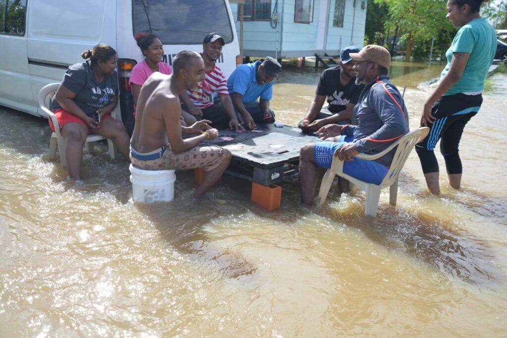
- More intense storms and flooding. Climate modelling and hazard assessments for Trinidad and Tobago indicate increased flood depths for return periods across coastal and urban areas — the same storms that cause immediate physical damage also disrupt services and health systems. (World Bank)
- Health & social risks. Heat stress, vector-borne disease risk (e.g., dengue), and threats to health infrastructure from floods and storm damage are already documented concerns for Caribbean health systems. International reporting has warned that many low-lying hospitals and clinics across the Caribbean are at risk from climate impacts. (ScienceDirect)
The case for community-driven responses
Top-down planning and infrastructure projects are necessary but insufficient. Effective climate resilience requires local knowledge, timely reports of events (e.g., localized flooding, blocked drains, beach erosion), and coordinated responses across neighbours, community organisations and municipal authorities. Community reporting can shorten response times, provide granular evidence for authorities (photos, repeated incident logs), and help prioritise limited public resources.
Digital civic tools that preserve privacy, verify participants, and create traceable tickets for issues transform anecdote into action — giving residents an auditable record they can present to councillors, regional corporations, and national agencies.

How HOATT’s features align with climate resilience needs
HOATT is positioned to be a practical bridge between residents and government agencies for climate adaptation and response. Key capabilities that make the platform useful for climate action include:
- Verified membership & privacy by default. HOATT’s registration and ID verification reduce trolling and increase trust — essential when escalating sensitive reports (e.g., pipeline leaks, illegal coastal dumping, or damage to critical infrastructure). (HOATT site features) (EMA)
- Private community groups and tiered access. Neighbourhood, estate and municipal groups allow residents to coordinate local adaptation actions (clean-ups, sandbagging, volunteer patrols) and invite specific officials or agencies into the conversation when escalation is needed. (HOATT features). (EMA)
- Structured support tickets & photo evidence. The ability to open a ticket with attachments means localized incidents (blocked drains, seawall breaches, landslides) are logged and traceable. This aids agencies in triaging and planning repairs or emergency response. (HOATT features). (EMA)
- Document & resource sharing. Groups can host preparedness checklists, evacuation maps, shelter locations, and local hazard maps — vital before, during and after extreme events.
- Local-to-state escalation path. By design, HOATT supports inviting council members and state agencies into targeted groups so concerns are not limited to social media posts and can be formally tracked.
Practical community applications and examples
1. Early flood reporting and triage
When heavy rains hit a neighbourhood, residents can immediately upload photos, location pins and short videos documenting depth and flow. A support ticket is created and visible to councillors and municipal works divisions — instead of multiple calls or scattered WhatsApp messages, the incident has a timestamped trail. The World Bank’s resilience work in Trinidad highlights the need for such localized, repeatable reporting mechanisms to prioritise interventions. (World Bank)
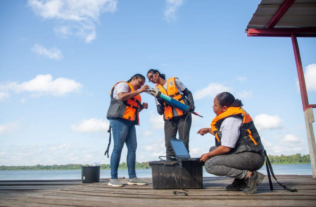
2. Coastal erosion monitoring and community science
Local volunteers can record daily or weekly shoreline photos and share them via HOATT groups. Collated over months, this grassroots dataset helps NGOs, academics and the EMA validate remote sensing and plan targeted interventions. Similar EO (earth observation) based studies for T&T have used local inputs combined with satellite data to model shoreline change and impacts. (NASA Technical Reports Server)
3. Protecting critical infrastructure
Hospitals and clinics in low-lying areas are climate-sensitive. Reporting and mapping by residents (e.g., documenting repeated flooding at clinic entrances) can support calls for protective infrastructure or temporary contingency planning while authorities prepare longer-term upgrades. International reporting has underscored the risk to health infrastructure across the Caribbean and the need for local evidence to prioritise resources. (Reuters)
4. Community preparedness & volunteer coordination
Prior to predicted storms or high tides, HOATT groups can coordinate volunteer teams, list basic supplies, maintain shelter rosters, and share evacuation routes—reducing chaos and improving outcomes in real time.

Measuring impact: collecting and using local data
For HOATT-enabled climate action to be effective, communities should adopt simple, standardised reporting templates (e.g., location, time, photos, severity). Aggregated, anonymised data can inform municipal planning: recurring hotspots for flooding, patterns of illegal dumping that exacerbate blocked drains, or areas where seawalls are failing.
International bodies and development banks increasingly emphasise the importance of bottom-up data for national adaptation planning and for making the case for finance. The World Bank and IDB case studies for the region show how local reporting and hazard mapping feed into national adaptation plans and infrastructure prioritisation. (World Bank)
Barriers and solutions to scaling community engagement
Digital divide. Not everyone has smartphones or reliable internet. Solutions include community hubs (libraries, civic centres) with access points, SMS-to-platform gateways, and training sessions run by HOATT volunteers and local NGOs.
Institutional buy-in. Some agencies may be slow to formally integrate community platforms into their workflows. Pilots that demonstrate measurable reductions in response time and improved targeting of limited resources can create momentum. The evidence from regional pilots in the Caribbean and Latin America shows that municipalities that adopt digital reporting often see faster resolution for routine maintenance tasks. (World Bank)
Sustained engagement. Groups may be active only during crises. Encouraging regular low-cost activities (like monthly cleanups, climate education sessions, or recognition programs for local volunteers) helps maintain networks so they are ready when extreme events occur.
Policy implications and the role of HOATT in adaptation planning
HOATT is not a substitute for robust public policy, infrastructure investment, or national climate finance. Rather, it is a complementary civic tool that enhances accountability and citizen participation — the “last-mile” connector between the lived environment and decision makers.
Policymakers and planners should:
- Recognise verified community reports as valid inputs for municipal work orders.
- Support integration of community data into national adaptation planning (NAPs) and early warning systems. Recent steps by the region toward formal NAPs underscore the importance of such local inputs. (UNDP Climate Promise)
- Invest in hybrid communication channels (digital + offline) so the most vulnerable are not excluded.
Final thought: local action, regional solidarity
Trinidad and Tobago shares its climate fate with neighbouring Caribbean islands. Adaptation success will come from coordinated national policy, regional cooperation and empowered local communities. Platforms like HOATT make it possible for residents to document climate impacts, coordinate responses, and press for accountability — and in doing so, they provide the data and social infrastructure that governments and international partners need to prioritise investments. In short: climate resilience begins at the street level, and digital civic tools can help ensure that street-level evidence reaches the state, the planners and the funders who can make a difference.
References & Sources
- IPCC, “Chapter 15: Small Islands,” AR6 WG2. (IPCC)
https://www.ipcc.ch/report/ar6/wg2/chapter/chapter-15/ - World Bank — Climate Knowledge Portal: Trinidad and Tobago (overview & sea-level projections). (Climate Knowledge Portal)
https://climateknowledgeportal.worldbank.org/country/trinidad-and-tobago - World Bank, “Resilience: Flood and hazard assessments for Trinidad and Tobago” (country report). (World Bank)
https://documents1.worldbank.org/curated/en/204471635293635337/pdf/360-Resilience-Trinidad-and-Tobago.pdf - UNDP Trinidad & Tobago country page / adaptation work. (UNDP Adaptation)
https://www.adaptation-undp.org/explore/latin-america-and-caribbean/trinidad-and-tobago - Inter-American Development Bank (IADB), “Climate Change Adaptation Case Study: Sea Level Rise in Trinidad and Tobago.” (IADB Publications)
https://publications.iadb.org/en/climate-change-adaptation-case-study-sea-level-rise-trinidad-and-tobago - EMA (Environmental Management Authority) — Trinidad & Tobago (agency site and submissions on climate inquiry). (EMA)
https://www.ema.co.tt/ - NASA / Earth Observation feasibility study on Trinidad & Tobago shoreline and sea-level (2025). (NASA Technical Reports Server)
(PDF — NASA NTRS) - IPCC Synthesis Report (AR6 SYR) — climate overview and risks. (IPCC)
https://www.ipcc.ch/report/ar6/syr/ - Reuters / UN reporting on Caribbean health infrastructure vulnerability to climate change. (Reuters)
https://www.reuters.com/world/americas/climate-change-threatens-low-lying-caribbean-hospitals-un-says-2024-05-28/


Responses